Stratonikeia (modern Eskihisar) was a prominent city in the interior of the ancient Carian region. Known as the “city of white marble,” it is distinguished by its continuous habitation since the Bronze Age. Stratonikeia is located in the west of Yatağan Plain on the northern slope of the Kadıkulesi Hill. The city is on major ancient trade routes connecting the Carian hinterland with the coast, specifically linking the Meander Valley to Mylasa and the port of Keramos. Its territory included two major religious sanctuaries: the Sanctuary of Hecate at Lagina (connected by a sacred road) and the Sanctuary of Zeus at Panamara.
The settlement has borne several names throughout its history. Hittite texts from the Late Bronze Age mention a city named Atriya, which some researchers identify as the precursor to Stratonikeia. Ancient sources record that the settlement was known as Chrysaoris (meaning “Golden Sword”) in the Archaic period and later as Idrias or Hecatesia in the Classical period. In the 3rd century BCE (c. 281–261 BCE), the city was refounded and renamed by a Seleucid king—either Seleucus I Nikator or his son Antiochus I Soter. It was named in honor of Queen Stratonike, the daughter of Demetrius Poliorcetes, who was first married to Seleucus I and later to his son Antiochus I. The city was named Hadrianopolis between 117 and 161 CE during the reigns of Hadrian and Antoninus Pius. Following the Turkish conquest in the late 11th century, the site was eventually named Eskihisar (Old Fortress).
Archaeological evidence indicates habitation in the territory dating back to the 3rd millennium BCE, but the flourishment of the settlement starts with the Hellenistic period as a Seleucid military colony (katoikia). It later came under Rhodian control until the Roman Senate declared Caria free in 167 BCE. During the wars against Mithridates VI (88 BCE), Stratonikeia remained loyal to Rome, despite suffering a siege. In 81 BCE, Sulla and the Roman Senate rewarded the city with autonomy, tax exemptions, and control over the port city of Keramos. The city was sacked by the Parthian troops in 40 BCE but recovered with Roman aid. It remained prosperous through the Late Antique period, serving as a bishopric, though it began to shrink in the 7th century CE.
Early travelers such as Evliya Çelebi (17th century), Richard Pococke (1740), and Richard Chandler (1764) visited the site, recording its ruins and inscriptions. Systematic excavations began in 1977, and continued almost uninterruptedly to the present day. Stratonikeia was placed on the UNESCO World Heritage Tentative List in 2015.
Gymnasion: Built in the 2nd century BCE, likely after the defeat of Rhodes (167 BCE), this is the largest known gymnasium in Asia Minor (105 x 267 meters).
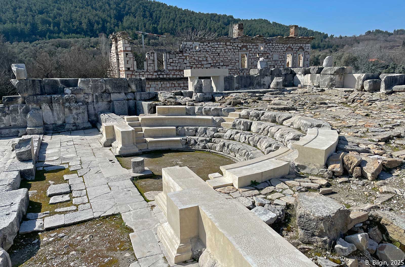
Bouleuterion: Located in the city center, this rectangular building features a semi-circular seating area (koilon). Its walls bear significant inscriptions, including the Price Edict of Diocletian (301 CE), which is the most complete copy known in Greek, and the Calendar of Menippos (1st century BCE), which lists the months and days of the local calendar.
North City Gate and Street: A monumental entrance featuring two arched passageways (dipylon) with a semicircular nymphaeum (fountain) between them. The gate led to a colonnaded street 8.70 meters wide. The two gates were likely used for separate processional entries from the sanctuaries of Hecate and Zeus.
Theater: A Greco-Roman type theater capable of holding approximately 9,000 to 12,000 spectators. It was dedicated to Dionysus and later renovated during the Augustan period.
Fortifications: The defensive system includes the “Kadıkulesi” refuge fortress and a 3,600-meter-long city wall built by the Seleucids (c. 260s BCE), featuring a rare “hexagonal tower” designed for artillery defense.
Turkish Period Structures: The site includes the Seljuk Bath (14th–15th century), the Şaban Ağa Mosque (Ottoman), and numerous traditional houses and village squares that integrate ancient marble blocks into their construction.




References:
Söğüt, B. 2019. Stratonikeia (Eskihisar) ve Kutsal Alanları, İstanbul.
Söğüt, B. 2020. “Stratoniceia’s Settlement History and Urban Fabric,” in The Carians, From Seafarers to City Builders, eds. O. J. Henry & A. Belgin-Henry, İstanbul, 488–503.
Söğüt, B. (ed.) 2024. From Antiquity to Modern Times Stratonikeia, İstanbul.
– Büyüközer, A. “Research in Stratonikeia’s Territory,” 94–121.
– Durnagölü, N. & E. Özdemir Candur. “The Gymnasion,” 190–201.
– Oğuzhanoğlu, U. “Bronze Age in the Yatağan Plain: The Building Blocks of Stratonikeie and Atriya,” 58–73.
– Özdemir, M. T. “The Hexagonal Tower in the Defensive System of Stratonikeia,” 170–192.
– Özdemir, M. T. & B. Söğüt. “The North City Gate and The North Street,” 246–259.
– Sarıiz, E. & A. T. Tek. “The Coins of Stratonikeia,” 362–369.
– Sezgin, T. “The Theater,” 216–233.
– Söğüt, B. “Settlement in Stratonikeia During and After the Iron Age,” 74–93.
– Söğüt, B. “The Bouleuterion,” 202–215.
– Türkoğlu, İ. “Stratonike, The Seleukid Quenn,” 30–43.
Images:
B. Söğüt, 2024
Bora Bilgin, 2025
Tayfun Bilgin, 2025